


Deskripsi Mobile Topographer GIS
The beloved choice of the professionals, Mobile Topographer ...meets... GIS.
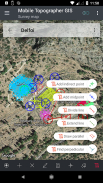
You can now perform a complete survey without any limitations into complexity or volume of data.
Try now Mobile Topographer GIS by using the three days free trial period. Just download the app and proceed with he subscription procedure. Although, you will be asked to provide billing information, you will NOT be charged before the end of the three days of the free trial period. You can cancel your subscription at any time during the three days trial period, free of charge. Charges will only occur, if at the end of the three days you still have an active subscription.
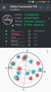
- Collect GNSS readings using increased accuracy (GPS, GLONASS, Galileo, Beidou, QZSS constellations supported).
- Connect your external GNSS receiver via mock locations and use Mobile Topogrpaher GIS as a processing unit.
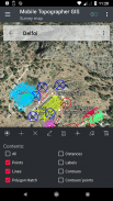
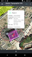
- Display data into WGS84 or you local projected CRS.
- Convert from WGS84 to local projected CRS and vice versa.
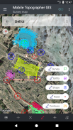
- Real time projection on map.
- *** NEW *** Custom image or WMS server as map background.
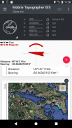
- Find a marked point in the real world by using "Drive me"
- Calculate Orthometric height on the fly using EGM model or local elevation grids where available.
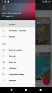
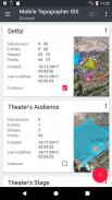
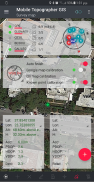
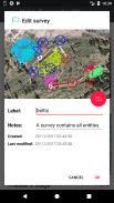
- Organize your work into Points - Shapes - Entities & Surveys. You can now create individual points, multi-point groups, multipart polylines, and multipart polygons with holes.
- Create a full drawing with as much details as you want.
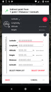
- *** NEW *** geodetic tools. Add indirect points via on of the following options: 1 point + Distance + Azimuth, 2 points + Distances + Select, 2 points + Azimuths, 3 points + Distances, Midpoint of line, Divide line, Extend line, Parallel line, Perpendicular to line.
- Nest your jobs, in any nesting level, to create a super-survey.
- Share data between jobs with active links.
- Exchange jobs between your mobile device and your desktop computer, with import - export functions using all common formats .txt, .csv, .kml, .gpx, .dxf and Shape files (.shp - .shx - .dbf)
- Collaborate with your partners by exchanging and sharing from one point to complete jobs.
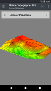
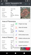
- Create the 3D terrain of an area by simply walking through it.
- Calculate contours and add them into your survey with lightning speeds.
- View a real 3D model directly into your device.
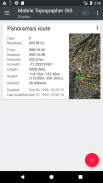
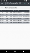
- Store a route with its data.
- Show GNSS satellites with signal info in both compass view or AR.
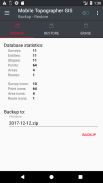
- Backup and restore your data using an SQL .db file.
Welcome to the era of mobile surveying...!
Find more about Mobile Topographer GIS in:
http://applicality.com/projects/mobile-topographer-gis/
Download the user's manual from:
http://applicality.com/app_documentation/web/MobileTopographerGIS_Manual.pdf
Pilihan tercinta profesional, Ponsel topographer ... Anda memenuhi ... GIS .
Anda sekarang dapat melakukan survei lengkap tanpa ada pembatasan dalam kompleksitas atau volume data.
Coba sekarang Ponsel topographer GIS dengan menggunakan tiga hari masa percobaan gratis. Hanya men-download aplikasi dan lanjutkan dengan dia prosedur berlangganan. Meskipun, Anda akan diminta untuk memberikan informasi penagihan, Anda TIDAK akan dikenakan biaya sebelum akhir tiga hari masa percobaan gratis. Anda dapat membatalkan langganan Anda setiap saat selama masa percobaan tiga hari, gratis. Biaya hanya akan terjadi, jika pada akhir dari tiga hari Anda masih memiliki langganan aktif.
- Kumpulkan GNSS pembacaan menggunakan akurasi meningkat (GPS, GLONASS, Galileo, Beidou, rasi bintang QZSS didukung).
- Hubungkan receiver GNSS eksternal Anda melalui lokasi mengejek dan menggunakan Ponsel Topogrpaher GIS sebagai unit pengolahan.
- Tampilan data ke CRS WGS84 atau Anda lokal diproyeksikan.
- Konversi dari WGS84 ke lokal diproyeksikan CRS dan sebaliknya.
- Real time proyeksi pada peta.
- *** NEW *** buatan gambar atau server WMS sebagai latar belakang peta.
- Cari titik ditandai di dunia nyata dengan menggunakan "Drive saya"
- Hitung orthometrik tinggi dengan cepat dengan menggunakan model EGM atau grid elevasi lokal di mana tersedia.
- Mengatur pekerjaan Anda ke dalam Points - Bentuk - Entitas & Survei. Sekarang Anda dapat membuat poin individu, kelompok multi-point, polyline multi, dan poligon multi dengan lubang.
- Buat gambar penuh dengan rincian sebanyak yang Anda inginkan.
- *** NEW *** alat geodesi. Menambah poin tidak langsung melalui atas dari pilihan berikut: 1 poin + Jarak + Azimuth, 2 poin + Jarak + Pilih, 2 poin + azimuths, 3 poin + Jarak, Midpoint dari garis, garis Divide, Memperpanjang garis, garis paralel, tegak lurus dengan garis .
- Nest pekerjaan Anda, di setiap tingkat bersarang, untuk membuat super-survei.
- Berbagi data antara pekerjaan dengan link aktif.
- pekerjaan Efek antara perangkat selular dan komputer desktop, dengan impor - fungsi ekspor menggunakan semua format umum .txt, .csv, .kml, .gpx, .dxf dan Shape file (shp - .shx - .dbf)
- Berkolaborasi dengan mitra Anda dengan bertukar dan berbagi dari satu titik untuk menyelesaikan pekerjaan.
- Buat medan 3D suatu daerah dengan hanya berjalan melalui itu.
- Hitung kontur dan menambahkan mereka ke dalam survei Anda dengan kecepatan kilat.
- Lihat model 3D nyata langsung ke perangkat Anda.
- Menyimpan rute dengan data.
- satelit Tampilkan GNSS dengan info sinyal di kedua tampilan kompas atau AR.
- Backup dan mengembalikan data Anda menggunakan file SQL Db.
Selamat datang di era survei ponsel ...!
Temukan lebih lanjut tentang Ponsel topographer GIS di:
http://applicality.com/projects/mobile-topographer-gis/
Ambil panduan pengguna dari:
http://applicality.com/app_documentation/web/MobileTopographerGIS_Manual.pdf


Mobile Topographer GIS - Informasi APK
Versi APK: 6.0.15Paket: com.applicality.mobiletopographergisAplikasi pada kategori yang sama
Anda juga mungkin suka...


